One of the first persons to be documented living in the Big Thompson Canyon was a trapper by the name of Frank Marvin. Frank was born in Ohio around the year 1829.1“Colorado State Census, 1885,” database with images, FamilySearch (https://familysearch.org/ark:/61903/3:1:939N-XSL8?cc=1807096&wc=M83M-T3V%3A149197401%2C149197402%2C149200101 : 1 April 2016), Pueblo > 5 > Population > image 3 of 14; citing NARA microfilm publication M158 (Washington D.C.: National Archives and Records Administration, n.d.). At the age of 29 he made his first venture into the west, as the chief engineer of an oxen team heading from the Missouri River to Fort Laramie.2Fort Collins Courier, 19 Jan. 1882. Colorado Historic Newspapers Collection. Colorado State Library. Frank was awestruck by the Rocky Mountains, and each time his job took him across the Great Plains his desire to live near the mountains grew. After working for several years he decided to try his luck and set up a camp in the Big Thompson Valley in 1863.3The Colorado Transcript, 4 Oct. 1882. Colorado Historic Newspapers Collection. Colorado State Library.
He lived a simple life as a trapper hunting “beaver, mink, muskrat, and skunks” in the Buckhorn and Big Thompson canyons.4Neville, Frend. (1956). Marvin Flats. Harold M. Dunning (Author), Over Hill and Vale; In The Evening Shadows of Colorado’s Longs Peak. Boulder, CO: Johnson Publishing Company. While trapping the Buckhorn he lived in an abandoned potato cellar near the confluence of the Buckhorn Creek and the Big Thompson River.5Neville, Frend. (1956). Marvin Flats. Harold M. Dunning (Author), Over Hill and Vale; In The Evening Shadows of Colorado’s Longs Peak. Boulder, CO: Johnson Publishing Company. The exact location of this cellar was described as being “just above where the Louden Ditch (or Sullivan ditch) leaves the Buckhorn” and on the property of George Galucia.6Neville, Frend. (1956). Marvin Flats. Harold M. Dunning (Author), Over Hill and Vale; In The Evening Shadows of Colorado’s Longs Peak. Boulder, CO: Johnson Publishing Company. Below is a map that shows the hypothesized location of Frank’s home in the Buckhorn, near the intersection of the Louden Ditch and the Buckhorn Creek and by the homestead of George Galucia.
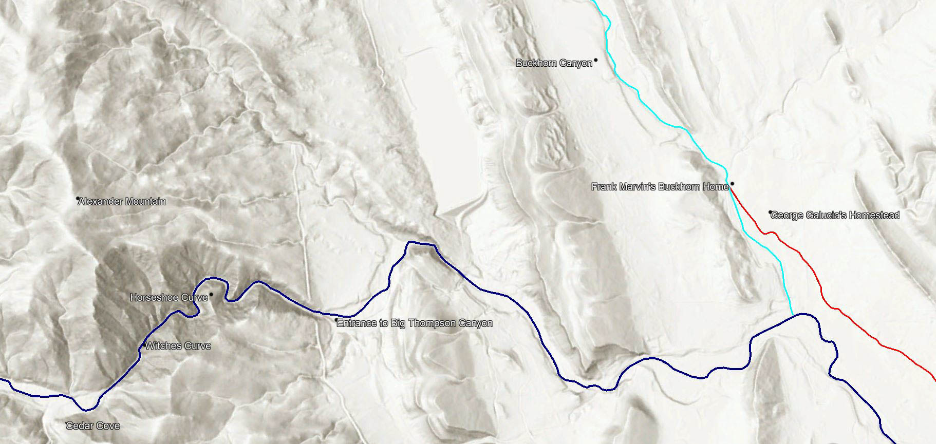
Current topographical map of the confluence of the Buckhorn Creek and Big Thompson River.7Esri. “Topographic” [basemap]. Scale Not Given. “World HIllshade”. 2021. (Jul 18, 2021). Using: Google Earth for Desktop, Version 7.3.4.8248: Google LLC, 2020.8Bureau of Land Management, State Volume Patent, General Land Office Record entry for George Galucia, Larimer, CO, no. 1750 Big Thompson River is highlighted in blue, Buckhorn Creek is highlighted in teal, the Louden Ditch (Sullivan Ditch) is highlighted in red. Frank Marvin’s hypothesized home is marked near the intersection of the Buckhorn Creek (Teal Line) and Louden Ditch (Red Line).
While trapping the Big Thompson River Frank had a different base of operation “one half mile south and east of Loveland’s municipal dam.”9Neville, Frend. (1956). Marvin Flats. Harold M. Dunning (Author), Over Hill and Vale; In The Evening Shadows of Colorado’s Longs Peak. Boulder, CO: Johnson Publishing Company. Loveland municipal dam, also known as the Idylwilde Dam, was located just upriver of Idlewild Subdivision until 2013. Coincidentally, “one half mile south and east” of where this dam once stood, is right in the middle of the Idlewild Subdivision, meaning Frank Marvin was the first resident of Idlewild.
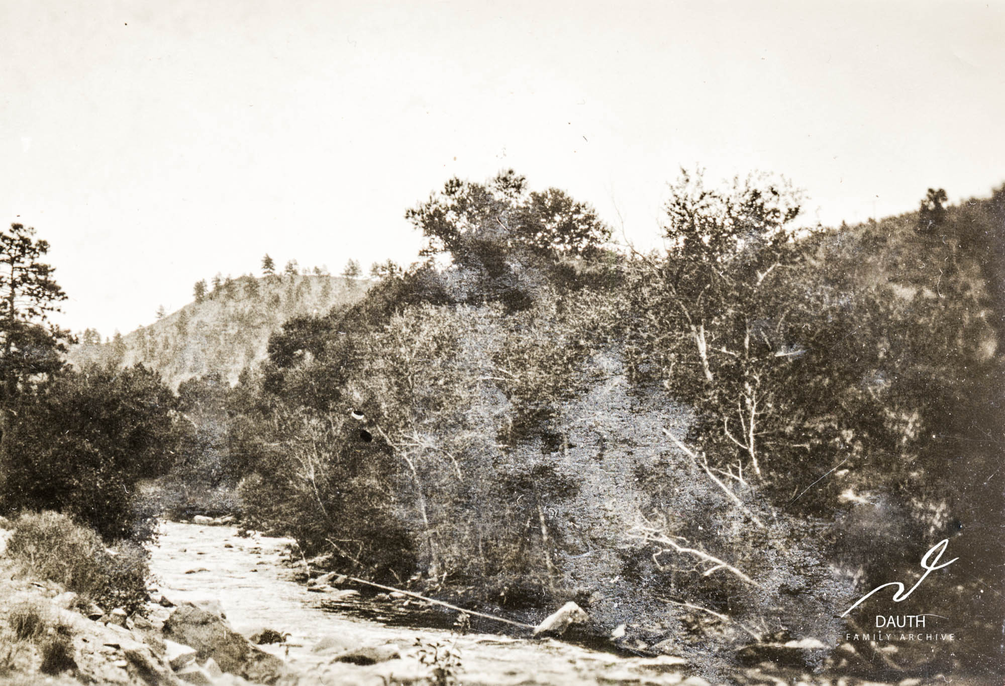
The earliest known photo of the land “one half mile south and east of Loveland’s municipal dam”, where Frank Marvin’s rock shelter would have been located. Idlewild Lodge is located further east, downstream and just around the curve. Photo was taken in 1924 before Ed Wild developed this land and long before Appleby built the Appleby Motel here. Lookout Mountain, of Loveland’s Round Mountain Nature Trail, is visible in the background.
Within this area, the exact location of Frank’s home is described as being “under a projecting rock in a small, deep canon.”10Neville, Frend. (1956). Marvin Flats. Harold M. Dunning (Author), Over Hill and Vale; In The Evening Shadows of Colorado’s Longs Peak. Boulder, CO: Johnson Publishing Company. Furthermore his home was described as being below the proposed route of John Rannells Toll Road. Specifically, from the article below, the road would go “down with a gentle grade into the canon above Marvin’s cabin.”11Loveland Reporter, 15 Dec. 1892. Colorado Historic Newspapers Collection. Colorado State Library.
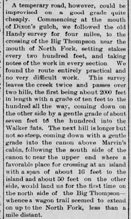
A temperary road, however, could be improvised on a good grade quite cheaply. Commencing at the mouth of Dixon’s gulch we followed the old Handy survey for four miles, to the crossing of the Big Thompson near the mouth of North Fork, setting stakes every two hundred feet, and taking notes of the work in every section. We found the route entirely practical and no very difficult work. This survey leaves the creek twice and passes over two hill, the first being about 2000 feet in length with a grade of ten feet to the hundred all the way, coming down on the other side by a gentle grade of about seven feet to the hundred into the Walker flats. The next hill is longer by not so steep, coming down with a gentle grade into the canon above Marvin’s cabin, following the south side of the canon to near the upper end where a favorable place for crossing at an island with a span of about 16 feet to the island and about 50 feet on the other side, would land us for the first time on the north side of the Big Thompson – whence a wagon trail seemed to extend on up to the North Fork, less than a mile distant.12Loveland Reporter, 15 Dec. 1892. Colorado Historic Newspapers Collection. Colorado State Library.
Loveland Reporter – December 15th, 1892
These descriptions of Frank Marvin’s home narrow its location down to a 400ft section of land below Rannells old toll road and within Idlewild’s deepest valley. The most livable area within this 400ft stretch of land has been redeveloped several times since the 1940s and its more than likely Marvin’s rock shelter was carved away to make room for the buildings that stand there today. However there is a small chance its still there, hidden in the overgrowth.
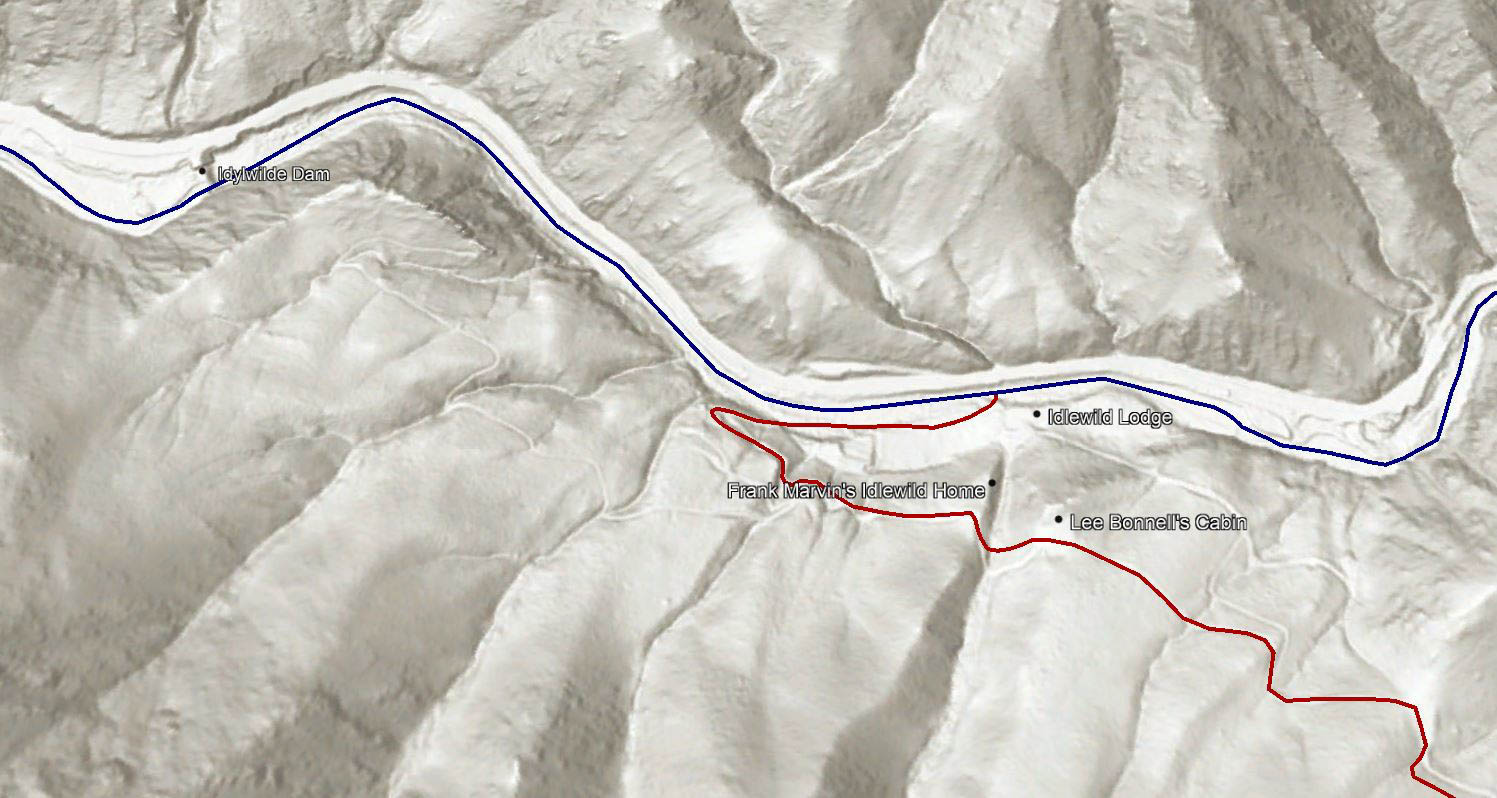
Current topographical map of the Idlewild Lodge area.13Esri. “Topographic” [basemap]. Scale Not Given. “World HIllshade”. 2021. (Jul 18, 2021). Using: Google Earth for Desktop, Version 7.3.4.8248: Google LLC, 2020. Big Thompson River is highlighted in blue and Rannells Toll Road is highlighted in red. Frank Marvin’s hypothesized home is marked within the deepest valley in the area and in the area below Rannells Toll Road. The exact location of his stone “cabin” within this area is unknown.
This valley and region being Frank Marvin’s stomping grounds led to people using his namesake to describe this area. The earliest recorded mention of this was in 1894, when John Rannells was building his toll road through Idlewild.14Loveland Reporter, 19 Jul. 1892. Colorado Historic Newspapers Collection. Colorado State Library. The local papers used the name “Marvin Flats” to describe this portion of the toll road.15Loveland Reporter, 19 Jul. 1892. Colorado Historic Newspapers Collection. Colorado State Library.
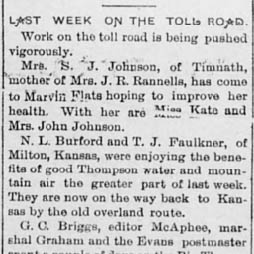
Mrs. S. J. Johnson, of Timnath, mother of Mrs. J. R. Rannells, has come to Marvin Flats hoping to improve her health. With her are Miss Kate and Mrs. John Johnson.16Loveland Reporter, 19 Jul. 1892. Colorado Historic Newspapers Collection. Colorado State Library.
Loveland Reporter – July 19, 1894
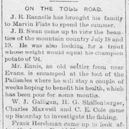
J. R. Rannells has brought his family to Marvin Flats to spend the summer.17Loveland Reporter, 26 Jul. 1892. Colorado Historic Newspapers Collection. Colorado State Library.
Loveland Reporter – July 26, 1894
Frend Neville, who would later purchase a large portion of the Idlewild homestead in the 1920s, wrote extensively on Marvin Flat’s in the book Over Hill and Vale. Within the book he recalls that the name “Marvin Flats” was used not only in reference to where Idlewild is today but also all of the region “from what is now Mont Rose Inn up to Crozier Mountain.” In other words Marvin Flats was the name used for all of the land from present day Cedar Cove to Drake.
- "Colorado State Census, 1885," database with images, FamilySearch (https://familysearch.org/ark:/61903/3:1:939N-XSL8?cc=1807096&wc=M83M-T3V%3A149197401%2C149197402%2C149200101 : 1 April 2016), Pueblo > 5 > Population > image 3 of 14; citing NARA microfilm publication M158 (Washington D.C.: National Archives and Records Administration, n.d.).
- Fort Collins Courier, 19 Jan. 1882. Colorado Historic Newspapers Collection. Colorado State Library.
- The Colorado Transcript, 4 Oct. 1882. Colorado Historic Newspapers Collection. Colorado State Library.
- Neville, Frend. (1956). Marvin Flats. Harold M. Dunning (Author), Over Hill and Vale; In The Evening Shadows of Colorado's Longs Peak. Boulder, CO: Johnson Publishing Company.
- Esri. “Topographic” [basemap]. Scale Not Given. “World HIllshade”. 2021. (Jul 18, 2021). Using: Google Earth for Desktop, Version 7.3.4.8248: Google LLC, 2020.
- Bureau of Land Management, State Volume Patent, General Land Office Record entry for George Galucia, Larimer, CO, no. 1750
- Loveland Reporter, 15 Dec. 1892. Colorado Historic Newspapers Collection. Colorado State Library.
- Loveland Reporter, 19 Jul. 1892. Colorado Historic Newspapers Collection. Colorado State Library.
- Loveland Reporter, 26 Jul. 1892. Colorado Historic Newspapers Collection. Colorado State Library.