Before the 1880s traversing the Big Thompson Canyon was a difficult task There were no roads in or around the canyon and most exploring could only be done when the river iced over allowing travel up the sheer cliffed narrows. The only people consistently in and out of the canyon were the trappers, loggers, and the most adventurous homesteaders. The demand for a road just wasn’t there.
Meanwhile Estes Park was quickly becoming a well known destination. Cabins were being built for tourists and ranchers were settling the valley. This interest in Estes Park led Larimer County commissioners to approve the construction of a road between Loveland and Estes Park in the 1880s. Three men, Gill Tower, Amos Penoyer, and Tom Quillen were paid $125 to hand carve a route through the mountains south of the Big Thompson. This road would be known as the Pole Hill Road, Bald Mountain Road, Larimer County Toll Road or the Estes Park Road.1Dunning, Harold Marion. Over Hill and Vale Volume II. Boulder, Colorado. Johnson Publishing Co., June. 25 1956, p. 30
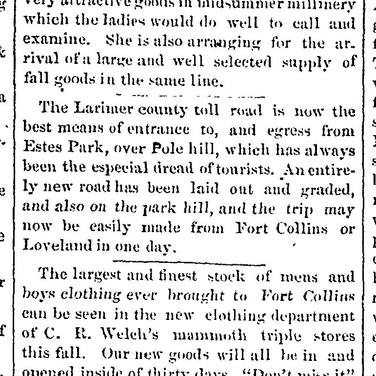
The Larimer county toll road is now the best means of entrance to, and egress from Estes Park, over Pole hill, which as always been the especial dread of tourists. An entirely new road has been laid out and graded, and also on the park hill, and the trip may now be easily made from Fort Collins or Loveland in one day.2Fort Collins Courier, 14 Aug. 1884. Colorado Historic Newspapers Collection. Colorado State Library.
Fort Collins Courier – August 14, 1884
The topographical map below of the Big Thompson Canyon was completed in 1884 by Civil Engineer H.P. Handy. For clarity the Estes Park Road is highlighted in green and the Big Thompson River is highlighted in blue. The beginning of the road is near “Mariana Lake” in western Loveland which is today known as “Mariano Reservoir” or “Boedecker Lake.” The road ends south of Estes Park at an intersection of a road named “Toll Road” which is most likely the North Saint Vrain toll road, today’s US 36.
1884 topographical map of the Big Thompson.3Handy, H. P. Map of Larimer County, Colorado: A.D.: showing public roads, irrigating canals, rail roads, road districts, school districts, voting precincts, and complete topography. [Colorado: publisher unknown, 1884] Map. https://www.loc.gov/item/2012586222/ The Estes Park Road, as it is called on this map, is highlighted in green and the Big Thompson River is highlighted in blue.
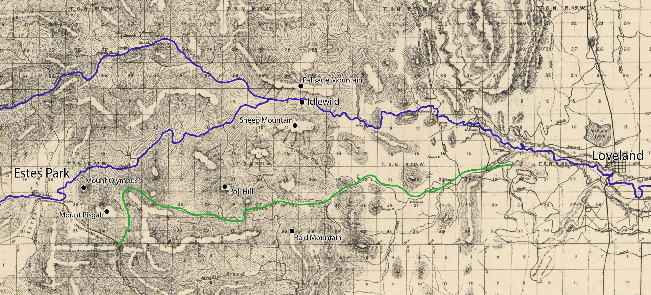
The current topographical map below highlights the remnants of Estes Park Road, or the Pole Hill Road as it is called on this map, in green. It begins in Loveland on present day County Road 29 about two miles west of where it began in 1884. This more detailed topographical map shows two notable ascents on this 18 mile route. The first is a 3 mile climb at Bald Mountain and the second is a grueling 6 mile climb up Poll Hill. The road ends at an intersection on US 36 which was the same road as the “Toll Road” in the topographical map from 1884.
Current topographical map of the Big Thompson Canyon.4Esri. “Topographic” [basemap]. Scale Not Given. “World HIllshade”. 2021. (May 25, 2021). Using: Google Earth for Desktop, Version 7.3.4.8248: Google LLC, 2020. Estes Park Toll road, called the Poll Hill Road today, is highlighted in green and the Big Thompson River is highlighted in blue.
While the Estes Park Toll route never provided direct access to the Big Thompson Canyon it did provide a jumping off point to many valleys and gulches that eventually lead to the Big Thompson River. One of the canyons first homesteaders, John R Rannells, saw this opportunity and decided to build his own toll road leading from the Pole Hill road to his homestead, which is today known as Cedar Cove.
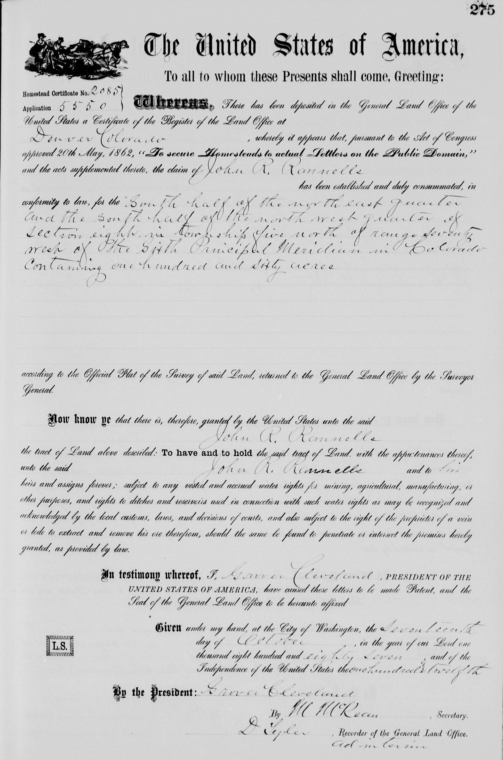
John R. Rannells homestead land patent filed on October 17th 1887 which encompasses the land on what is today known as Cedar Cove.5Bureau of Land Management, State Volume Patent, General Land Office Record entry for John R Rannells Larimer, CO, no. 2085 Bureau of Land Management, State Volume Patent, General Land Office Record entry for John R Rannells Larimer, CO, no. 2085
The first public mention of Rannells Toll Road was on May 13th, 1892, with the announcement of a corporation that aimed “to build a toll road from Loveland to Middle Park [Estes Park], following the Big Thompson River…”
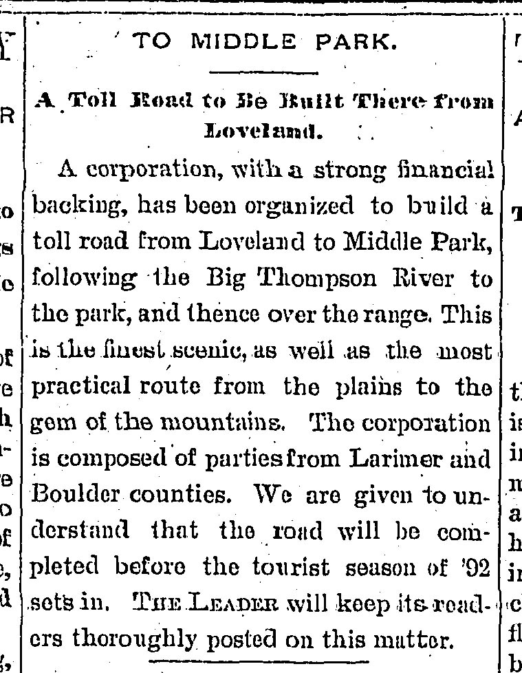
To Middle Park – A Toll Road to Be Built There from Loveland
A corporation, with a strong financial backing, has been organized to build a toll road from Loveland to Middle Park, following the Big Thompson River to the park, and thence over the range. This is the finest scenic, as well as the most practical route from the plains to the gem of the mountains. the corporation is composed of parties form Larimer and Boulder counties. We are given to understand that the road will be completed before the tourist season of ’92 sets in. The Leader will keep its readers thoroughly posted on this matter.6The Leader, 13 May. 1892. Colorado Historic Newspapers Collection. Colorado State Library.
The Leader – May 13th, 1892
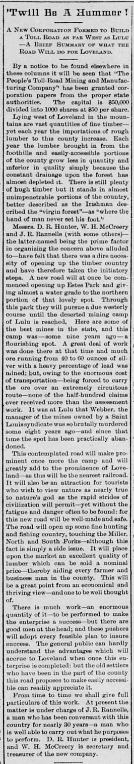
John Rannells would partner with D. R. Hunter and W. H. McCreery to create “The People’s Toll-Road Mining and manufacturing Company.” They declared their purpose was “opening up the timber country” west of Loveland, and to “make prominent once more the [mining] camp” of Lulu city. They also added that their road would “be an attraction for tourists” and “open up some fine hunting and fishing country.” The full declaration is below:
Twill Be A Hummer!
A New Corporation Formed to Build a Toll Road as far West as Lulu —A Brief Summary of what the Road Will do for Loveland.
By a notice to be found elsewhere in these columns it will be seen that “The People’s Toll-Road Mining and Manufacturing Company’’ has been granted corporation papers from the proper state authorities. The capital is $50,000 divided into 1000 shares at $50 per share. Lying west of Loveland in the mountains are vast quantities of fine timber—yet each year the importations of rough lumber to this county increase. Each year the lumber brought in from the foothills and easily-accessible portions of the county grow less in quantity and inferior in quality simply because the constant drainage upon the forest has almost depleted it. There is still plenty of hugh timber but it stands in almost unimpenetrable portions of the country, better described as the Irishman described the “virgin forest”—as “where the hand of man never set hie foot.’’
Messrs. D. R. Hunter, W. H. McCreery and J. R. Rannells (with some others) — the latter-named being the prime factor in organizing the concern above alluded to —have felt that there was a dire necessity of opening up the timber country and have therefore taken the initiatory steps. A new road will at once be commenced opening up Estes Park and giving almost a water grade to the northern portion of that lovely spot. Through this park they will pursue a due westerly course until the deserted mining camp of Lulu is reached. Here are some of the best mines in the state, and this camp was —some nine years ago—a flourishing spot. A great deal of work was done there at that time and much ore running from 40 to 60 ounces of silver with a heavy percentage of lead was mined: but, owing to the enormous cost of transportation—being forced to carry the ore over an extremely circuitous route—none of the half-hundred claims ever received more than the assessment work. It was at Lulu that Webber, the manager of the mines owned by a Saint Lou is syndicate was so brutally murdered some eight years ago—and since that time the spot has been practically abandoned.
This contemplated road will make prominent once more the camp and will greatly add to the prominence of Loveland—as this will be the nearest railroad. It will also be an attraction for tourists who wish to view nature as nearly true to nature’s god as the rapid strides of civilization will permit—yet without the fatigue and danger often to be found: for this new road will be well-made and safe. The road will open up some fine hunting and fishing country, touching the Miller, North and South Forks—although this fact is simply a side issue. It will place upon the market an excellent quality of lumber which can be sold a nominal price—thereby aiding every farmer and business man in the county. This will be a great point from an economical and thriving view—and one to be well thought of.
There is much work—an enormous quantity of it—to be performed to make the enterprise a success —but there are good men at the head; and these pushers will adopt every feasible plan to insure success. The general public can hardly understand the advantages which will accrue to Loveland when once this enterprise is completed: but the old settlers who have been in the part of the county this road proposes to make easily accessible can readily appreciate it.
From time to time we shall give full particulars of this work. At present the matter is under charge of J. R. Rannells, a man who has been conversant with this country for nearly 30 years—a man who is well able to carry out what he purposes to perform. D. R. Hunter is president, and W. H. McCreery is secretary and treasurer of the new company.7The Leader, 26 May. 1892. Colorado Historic Newspapers Collection. Colorado State Library.
Loveland Reporter – May 26, 1892
Identifying the route of Rannells Toll Road involves a little guess work because no such road exists today nor in any found historical maps of the canyon. The article below written when Rannells was constructing the road describes the roads starting point and a location it was passing through.
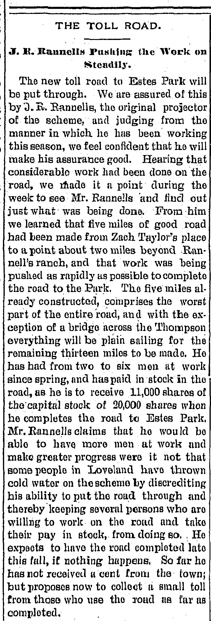
THE TOLL ROAD.
J.R. Rannells Pushing the Work on Steadily.
The new toll road to Estes Park will be put through. We are assured of this by J. R. Rannells, the original projector of the scheme, and judging from the manner in which he has been working this season, we feel confident that he will make his assurance good. Hearing that considerable work has been done on the road, we made it a point during the week to see Mr. Rannells and find out just what was being done. From him we learned that five miles of good road has been made from Zach Taylor’s place to a point about two miles beyond Rannell’s ranch, and that work was being pushed as rapidly as possible to complete the road to the Park. The five miles already constructed, comprises the worst part of the entire road, and with the exception of a bridge across the Thompson everything will be plain sailing for the remaining thirteen miles to be made. He has had from two to six men at work since spring, and has paid in stock in the road, as he is to receive 11,000 shares of the capital stock of 20,000 shares when he completes the road to Estes Park. Mr. Rannells claims that he would be able to have more men at work and make a greater progress where it not that some people in Loveland have thrown cold water on the scheme by discrediting his ability to put the road through and thereby keeping several persons who are willing to work on the road and take their pay in stock, from doing so. He expects to have the road completed late this fall, if nothing happens. So Far he has not received a cent from the town; but proposes now to collect a small toll from those who use the road as far as completed.8The Leader, 30 Jun. 1893. Colorado Historic Newspapers Collection. Colorado State Library.
The Leader – June 30, 1893
Rannells Toll Road began at “Zach Taylor’s” place which was a property owned by Zachary Taylor that bordered the Estes Park Toll road. Zachary Taylor’s original home, named Cliff Cottage, still stands today at 9327 Poll Hill Road, which means the start of the road is within this area. Furthermore we know that the road passed through Rannell’s ranch, which is located at present day Cedar Cove. Cedar cove is northwest of this location, which means the toll road mostly likely went northward from Zachary Taylor’s home. The article below discussing an incident that occurred on Rannells Toll Road gives another clue as to where the road passed.
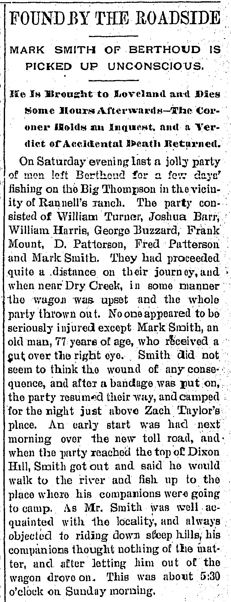
FOUND BY THE ROADSIDE
MARK SMITH OF BERTHOUD IS PICKED UP UNCONSCIOUS.
He Is Brought to Loveland and Dies Some Hours Afterwards-The Coroner Holds an Inquest. and a Verdict of Accidental Death Returned.
On Saturday evening last a jolly party of men left Berthoud for a few days fishing on the Big Thompson in the vicinity of Rannell’s ranch. The party consisted of William Turner, Joshua Barr, William Harris, George Buzzard, Frank Mount, D. Patterson, Fred Patterson and Mark Smith. They had proceeded quite a distance on their journey, and when near Dry Creek, in some manner the wagon was upset and the whole party thrown out. No one appeared to be seriously injured except Mark Smith, an old man, 77 years of age, who received a cut over the right eye. Smith did not seem to think the wound of any consequence, and after a bandage was put on, the party resumed their way, and camped for the night just above Zach Taylor’s place. An early start was had next morning over the new toll road, and when the party reached the top of Dixon Hill, Smith got out and said he would walk to the river and fish up to the place where his companions were going to camp. As Smith was well acquainted with the locality, and always objected to riding down steep hills, his companions thought nothing of the matter, and after letting him out of the wagon drove on. This was about 5:30 o’clock on Sunday morning.9The Leader, 7 Jul. 1893. Colorado Historic Newspapers Collection. Colorado State Library.
The Leader – July 7, 1893
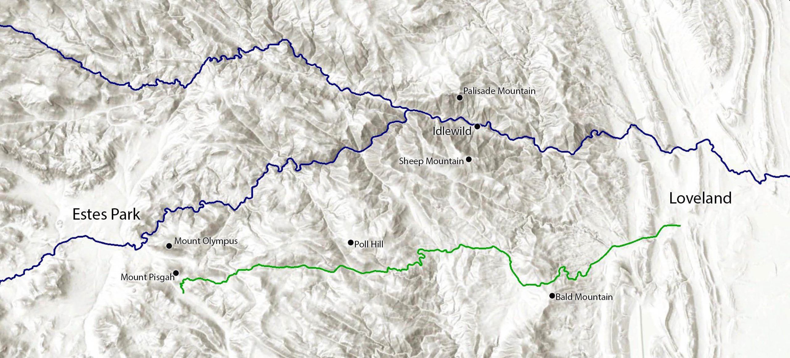
The location of Dixon Hill is mentioned as being en route. Unfortunately Dixon Hill is not plotted on any topographical maps from any time period in this area. There is however a Dixon Gulch, spelled as Dickson Gulch on current topographical maps, that names the valley that leads into Cedar Cove from Zachary Taylor’s home. Dixon Hill may refer to the unnamed hill at the top of the gulch which would narrow down the road to the marked trail highlighted in red below.
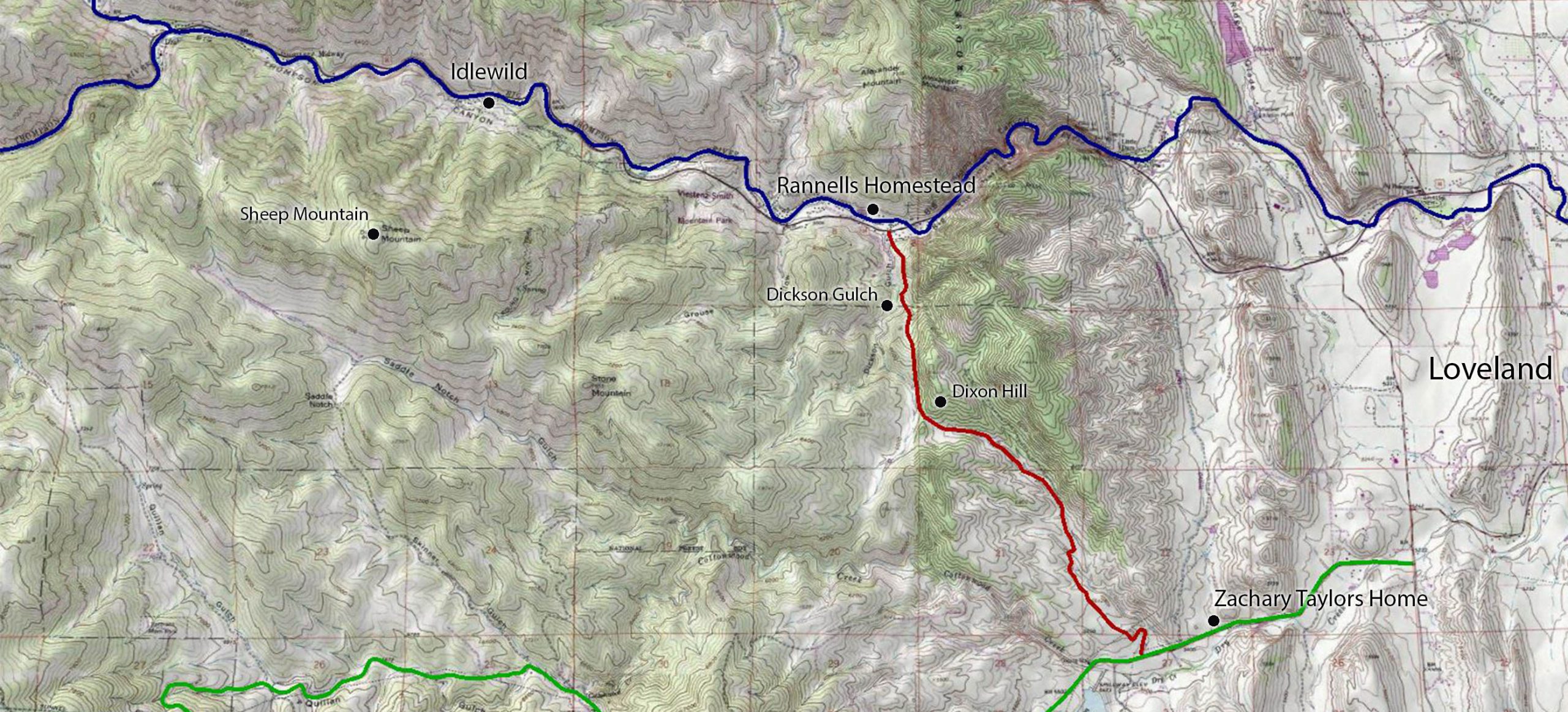
Current topographical map of the Big Thompson Canyon.10Esri. “Topographic” [basemap]. Scale Not Given. “Earth Point Topo Map”. 2021. (May 25, 2021). Using: Google Earth for Desktop, Version 7.3.4.8248: Google LLC, 2020. Big Thompson River is highlighted in blue, Poll Hill road in green and hypothesized route of Rannells Toll Road up to Rannells homestead highlighted in red.
This road is today called Bear Track Road and appears to be a primitive road that passes through both private and public land. After the 2013 Big Thompson Flood this route was used by first responders to get around the damage of US 34 in the narrows.
From here we know that Rannells built his toll road upriver towards Estes Park. In 1893 he had reached a place “two miles beyond Rannell’s ranch” which would be in the valley of Louis Papa’s cabin, today known was Viestenz-Smith Mountain Park. The last piece of the puzzle is found in the book “History of the Big Thompson Canyon” by the Drake Home Demonstration Club:
Mrs. Van Bramer, daughter of Frank Bartholf, homesteaded this land and operated a summer resort — “Idle Wild”, and was a part of the old toll road, the entrance being at Mont Rose Inn. Of Course the road has been changed many times up to the present time. It used to come over the hill where the power plant is now located and was much more scenic than the paved road which now follows the river.11Drake Home Demonstration Club, “History of the Big Thompson Canyon” 1939. p10
“History of the Big Thompson Canyon” by the Drake Home Demonstration Club. 1939 p10
The toll road mentioned is likely Rannells Toll Road since it began at Mont Rose Inn which was at Cedar Cove and passed the power plant, which was located at Viestenz-Smith Mountain Park. From the description of it passing “over the hill where the power plant is” likely means it followed the same route that is now the Round Mountain Nature Trail. Below is the final hypothesized route of Rannells Toll Road up to Idlewild.
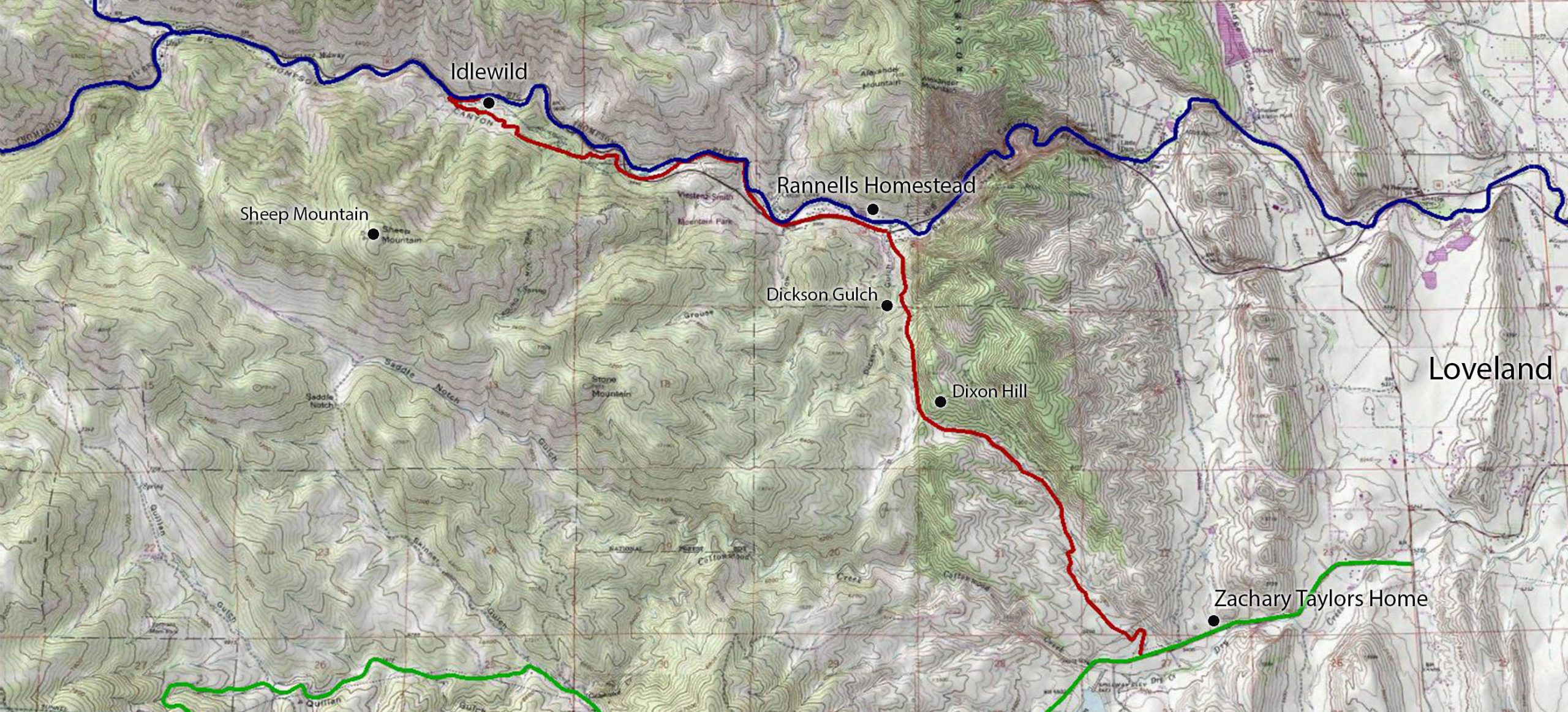
Current topographical map of the Big Thompson Canyon.12Esri. “Topographic” [basemap]. Scale Not Given. “Earth Point Topo Map”. 2021. (May 25, 2021). Using: Google Earth for Desktop, Version 7.3.4.8248: Google LLC, 2020. Big Thompson River is highlighted in blue, Poll Hill road in green and hypothesized route of Rannells Toll Road up to Idlewild highlighted in red.
This route places Idlewild at 7.1 miles from the Poll Hill road. Rannells would reach the 7 mile mark by July 5th 1894:
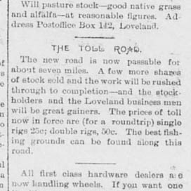
The Toll Road
The new road is now passable for about seven miles. A few more shares of stock sold and the work will be rushed through to completion-and the stockholders and the Loveland business men will be great gainers. The prices of toll now in force are (for the roundtrip) single rigs 25c; double rigs, 50c. The best fishing grounds can be found along the road.131894-07-05 – Loveland Reporter – Rannells Toll Road Reaches Idlewild
Loveland Reporter – July 5, 1894
The toll road would continue to be built up the canyon to present day Drake and then through the North Fork towards present day Glen Haven. Although the official name for the road was “The People’s Toll Road”, many would refer to it as “Rannells Toll Road” because John Rannells was the driving force for the roads construction.
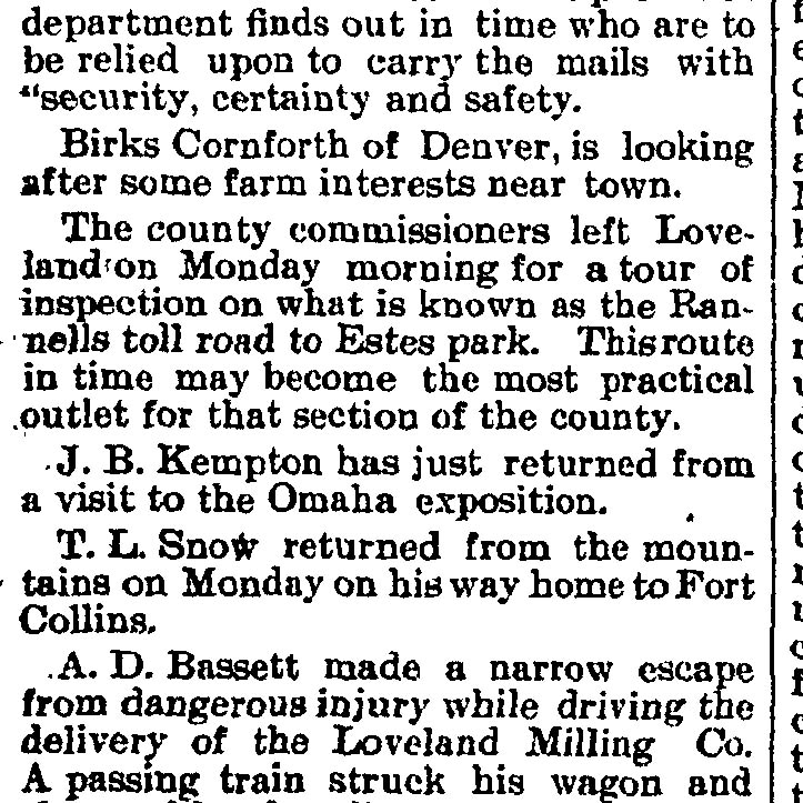
The county commissioners left Loveland on Monday morning for a tour of inspection on what is known as the Rannells toll road to Estes park. This route in time may become the most practical outlet for that section of the county.14Fort Collins Courier, 13 Oct. 1898. Colorado Historic Newspapers Collection. Colorado State Library.
Fort Collins Courier – October 13th, 1898
Rannells Toll Road was in service from 1893-1903, up until the completion of the Riley Road in 1904.
MLA Format
Idlewild Lodge. "Rannells Toll Road To Idlewild." Idlewild Lodge, Dauth Family Archive, 2 Apr. 2021, https://idlewildlodge.github.io/rannells-toll-road-to-idlewild/. Accessed 4 Jul. 2023.
⧉
APA Format
Idlewild Lodge. (2021, April 2) Rannells Toll Road To Idlewild. Retrieved July 4, 2023, from https://idlewildlodge.github.io/rannells-toll-road-to-idlewild/.
⧉
Chicago Format
Idlewild Lodge. "Rannells Toll Road To Idlewild." Idlewild Lodge. Dauth Family Archive, April 2, 2021. Accessed July 4, 2023. https://idlewildlodge.github.io/rannells-toll-road-to-idlewild/.
⧉